From Local Streets to State Headlines – California’s News Starts Here

3.8-Magnitude Earthquake Shakes Southern Kern County Near Bakersfield
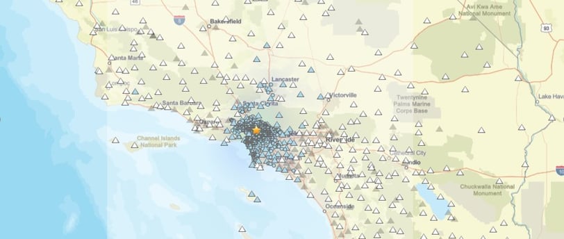
BAKERSFIELD, Calif. — A 3.8-magnitude earthquake jolted southern Kern County on Monday afternoon, sending light tremors through communities near Mettler and the Grapevine, about 15 miles south of Bakersfield. The quake struck at 12:09 p.m. Pacific Time, according to the United States Geological Survey (USGS).
5/20/20252 min read
Minor Quake Felt Across Kern, Los Angeles, and Ventura Counties on Monday Afternoon
BAKERSFIELD, Calif. — A 3.8-magnitude earthquake jolted southern Kern County on Monday afternoon, sending light tremors through communities near Mettler and the Grapevine, about 15 miles south of Bakersfield. The quake struck at 12:09 p.m. Pacific Time, according to the United States Geological Survey (USGS).
Epicenter Details and Affected Areas
The epicenter was located west of Mettler, near the busy Grapevine corridor, at a depth of approximately four miles. Although the earthquake was classified as minor, residents across Kern, Los Angeles, and Ventura counties reported feeling the shaking.
Responses collected by the USGS indicated light tremors were noticed even in Los Angeles suburbs and parts of Ventura County, though no injuries or major damage were reported.
Image Source: United States Geological Survey (USGS)
https://earthquake.usgs.gov/earthquakes/eventpage/ci41070112/shakemap/intensity
Expert Insights on the Earthquake
“This is a pretty small magnitude earthquake... not really even an earthquake we expect many people to feel unless you live pretty close by,” said Dr. Matthew Herman, Assistant Professor of Geological Sciences at California State University, Bakersfield.
Dr. Herman also pointed out the proximity of the quake to the San Andreas Fault, emphasizing the region’s high seismic activity. He added, “This is an area that has quite a bit of seismicity. While smaller quakes like this are frequent, larger events can happen too, like last year’s 5.2-magnitude earthquake in the same region.”
Aftershocks and Seismic Forecast
Following the main shock, aftershocks in the magnitude 2 range were reported. According to the Southern California Seismic Network, there's a 5% chance of a larger earthquake occurring in the coming days, though the likelihood typically decreases over time.
Southern Kern County is part of a broader area in California prone to earthquakes, and residents are frequently reminded of the importance of earthquake preparedness.
Impact on Travel and Infrastructure
The quake’s timing—just ahead of the Memorial Day travel rush—prompted precautionary inspections at Bakersfield Municipal Airport and other regional airports. While no structural damage was found, some flights experienced brief delays, and passengers were encouraged to monitor airline updates.
This incident underscores the importance of travel safety during seismic events, especially in earthquake-prone areas like Southern California.
Community and Emergency Response
Emergency dispatch centers across Bakersfield and Kern County received a surge of calls shortly after the tremor. However, no injuries or major structural damage were reported.
Local authorities reminded residents and travelers to remain vigilant and to follow guidance from emergency management agencies, particularly in the event of aftershocks.
Summary: Earthquake in Southern California
A 3.8-magnitude earthquake struck near Mettler, 15 miles south of Bakersfield, at 12:09 p.m. Monday.
Felt across Kern, Los Angeles, and Ventura counties with no significant damage reported.
Aftershocks were recorded; seismic experts advise continued earthquake preparedness.
Airports conducted inspections, resulting in minor flight delays.
Residents are encouraged to monitor USGS earthquake updates and stay alert.
Stay Informed and Prepared
As California continues to experience frequent seismic activity, it’s vital for residents and visitors to stay informed through trusted sources like the USGS Earthquake Map and local government advisories. Emergency preparedness kits, earthquake drills, and awareness campaigns remain essential tools in minimizing risks.
Sources:
USGS Earthquake Map
Los Angeles Times – California Earthquake Coverage
Insights
Stay informed with California's latest news updates.
Support
© 2025. All rights reserved.